

MONGOLIA DESTINATION
Mongolia is truly one of the world's last undiscovered travel destinations and the safest country to visit. It is a land where you can experience wide-open spaces, cobalt blue skies, forests, deserts, crystal clear rivers and lakes, and the traditional hospitality of the nomads. Permanent dwellings are few and far between, fences even fewer and the land is owned by the people, like one large National Park. As a tremendous destination to experience the outdoors, Mongolia also boasts of unique history dating back to the Mongol Empire of Genghis Khan. Simply put, it is a land of adventure, horses, nomads, and blue sky.
-
Western Mongolia
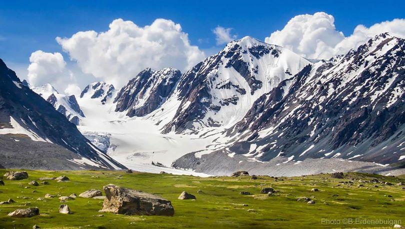 Western Mongolia – Far western part of Mongolia is the most beautiful travel destination. It is home to the world rare wild species, numerous ethnic groups and snow capped majestic mountains. The most remote region of the country, that includes many National Parks, Strictly Protected areas, Nature Reserves, Nature Monuments, also home to the highest mountain Altai Mountain Range, Khuiten peak(4374 m), biggest saltwater lake Uvs Lake Basin (inscribed in "UNESCO World heritage sites" in 2003) and many smaller lakes, mountains, rivers, forests, and steppe.
Scenic mountainous region of western Mongolian territory includes Zavkhan, Gobi-Altai, Khovd, Uvs, Bayan-Ulgii provinces. Spread throughout the region are countless archeological sites with ancient petroglyphs, cave paintings, standing stone monuments, monasteries, and ancient forts that date back as far as 10,000 years.
Kazakh people, famous for their hospitality and generosity, take pleasure in poetry and music. Over three hundred Mongolian Kazakhs now practice the art of eagle hunting, a sport that goes back two thousand years.
Highlights: Kazakh people, Eagle hunters, Golden Eagle festival, hiking and climbing at Altai Tavan Bogd Mountains.
Western Mongolia – Far western part of Mongolia is the most beautiful travel destination. It is home to the world rare wild species, numerous ethnic groups and snow capped majestic mountains. The most remote region of the country, that includes many National Parks, Strictly Protected areas, Nature Reserves, Nature Monuments, also home to the highest mountain Altai Mountain Range, Khuiten peak(4374 m), biggest saltwater lake Uvs Lake Basin (inscribed in "UNESCO World heritage sites" in 2003) and many smaller lakes, mountains, rivers, forests, and steppe.
Scenic mountainous region of western Mongolian territory includes Zavkhan, Gobi-Altai, Khovd, Uvs, Bayan-Ulgii provinces. Spread throughout the region are countless archeological sites with ancient petroglyphs, cave paintings, standing stone monuments, monasteries, and ancient forts that date back as far as 10,000 years.
Kazakh people, famous for their hospitality and generosity, take pleasure in poetry and music. Over three hundred Mongolian Kazakhs now practice the art of eagle hunting, a sport that goes back two thousand years.
Highlights: Kazakh people, Eagle hunters, Golden Eagle festival, hiking and climbing at Altai Tavan Bogd Mountains.
Meet Kazakh People, Experience Life As An Eagle Hunter

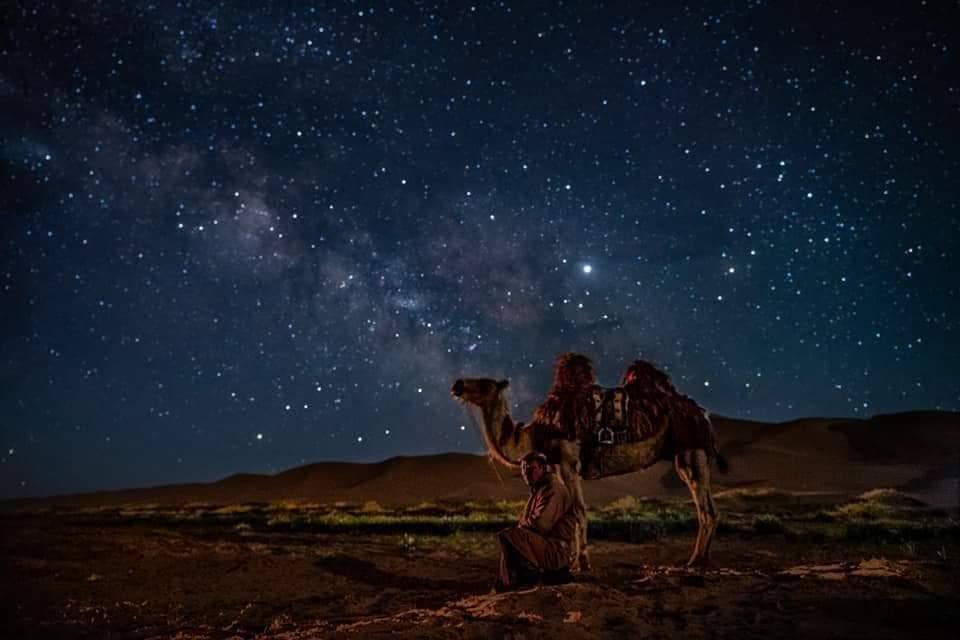
Of course, the highlight of our trip is meeting the Kazakh people and their true friend Golden Eagles. Rise bright and early for a full day with nomads! For centuries, Nomadic tradition have survived off the land, relying on their livestocks for transport, milk, cheese, meat, and even materials like dung for fuel, antlers for tools, and hair for clothes. The nomad herders are extremely hospitable and enthusiastic about sharing their way of life. Riding and milking livestocks are must-try activities — and we might discover a natural nomadic herder among us!
Golden Eagle Festival

Travel Mongolia and enjoy Golden Eagle Festival with us! This unforgettable festival displays the best Kazakh hunters’ supreme skills and therefore you can witness an art of the man and bird friendship at the same time. For last few years, local Kazakh people who lives in Bayan-Ulgii province, organize an important celebration for the benefits of next generation local community and international falconry. Eagle Hunting Festival, a colorful and picturesque event attracting the best hunters and birds in early October. The Golden Eagle Festival became one of the main events to captivate photographers, researchers and travelers to Mongolia. This unforgettable festival displays the best Kazakh hunters’ supreme skills and therefore you can witness an art of the man and bird friendship at the same time.
Altai Tavan Bogd National Park

Altai Tavan Bogd National Park is located on the Western most point of Mongolia in Bayan-Ulgii Province. This vast mountainous park borders China and Russia with views of Kazakhstan from the highest peak in Mongolia. The snow-capped Kuiten Mountain, 4374 m (14,201 ft), is the highest of the five peaks of Tavan Bogd Mountains (literally ‘5 Saints’) that gives the park its name. It covers an area of 630,000 hectare and is home to three large freshwater lakes and 34 glaciers, plus several waterfalls. The largest, Pontuninii Glacier, covers 23 sq km. Tavan Bogd Mountains is considered sacred to local Kazakhs, Tuvans, and Mongolians. Also, there are over 10.000 of petroglyphs (Rock paintings) in 15 km of river valley which is registered in World Heritage Site, UNESCO.
Khyargas lake

It is a one of the Mongolian largest lakes, covering 1.406 square kilometers. It is 75 kilometers long, 31 kilometers wide and 80 meters deep. The lake surface is at 1.028 meters above the sea level. The water is brackish. And has rare fish such as Mongolian Grayling.
Ulaagchiin Khar Lake

Ulaagchnii Khar Nuur lake is considered as one of the oldest lakes in the world, surrounded by golden sand dunes and snow caped Mt. Otgon Tenger. The lake has been protected as Strictly Protected Area since 2010 and one of the most unique nature scenery and fresh water Lake of Mongolia. In July there is an amazing festival is held on the shore of the lake, Called Nomadic Culture Festival. Local nomads who gather from nearby region and celebrate this festival to show their heritage and culture so you can take a journey back to the ancient time to experience what the nomads practiced and what their unique culture was. Photographing around Ulaagchiin Khar Lake is one of the should do activities, you can take amazing captures such as competitions, performances and shows of Nomadic Culture festival along with beautiful natural scenery.
Khurgan and Khoton Lakes

The Khoton and Khurgan Lakes are second largest and clearest of all lakes in Mongolia. The average depth is 26 m, the maximum depth is approximately 58 m. The landscape around the lakes is stunning: with forests and the snow-capped Altai Mountains. Khoton and Khurgan Lakes are home to the grayling (thymallus arcticus) and the lenok (brachymystax lenok). The lakes are located in an intermontane tectonic depression in the northern portion of the Mongolian Altai Region. The lakes themselves, as well as the mountain rivers which feed the lakes, offer excellent sport fishing in a rugged and virtually unpopulated area. Surface area is 50.1 km2; the average depth is 26.6 m; the maximum depth is approximately 58 m. Khoton lake has one island which is covered by woods. The system of Khoton and Khurgan lakes, connected by a wide channel, is the source of the Hovd river which drains the whole Mongolian Altai. Lake Khoton was formed by glacier blockages. Khurgan lake is the lowest point of Altai Tavan Bogd National park.
Mukhart - Muddy River

Mukhart River starts silently flowing from bottom of the Bor Khyar Sand dunes the 400 meter high. There is a lush tree along the river valley, where there are a variety of mangoes, corks, and banners. There is a unique natural landscape, with sandy waters like a sandy semicircular amphitheater. Mukhart River is without a doubt one of the key attractions in the vast steppes of Mongolia. This river itself is a masterpiece of nature, as it flows from within the sands. Numerous berries such as blueberries and sweetbriers grow in this region. The locals highly recommend stopping by this beautiful lake for refreshments and relaxation. With its extraordinary features, and is a beautiful oasis in the desert.
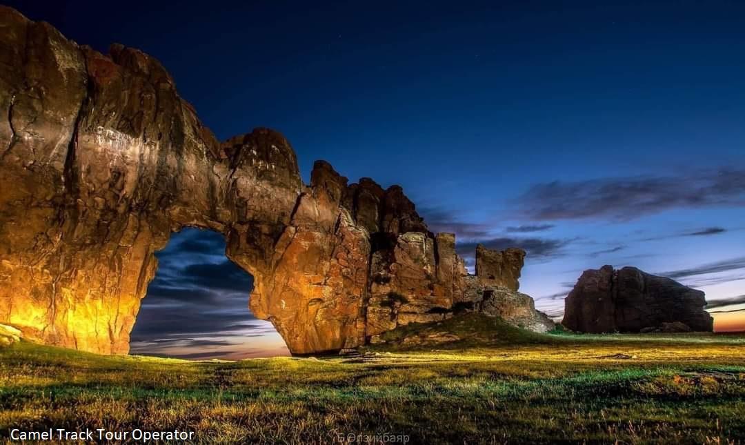
Senjit Khad - Senjit Rock

Located 95 kilometres (59,03 miles) North Uliastai, the rocky formations of Senjit Khad have a very interesting shape. In effects, the often violent wind coming from Gobi Desert drilled the rock in several places and, in the middle of the rock, there is a natural 6-metre-wide (19,69 feet) and 3,5-metre-high (11,48 feet) arch. This rocky formation is located on top of a hill from where you'll enjoy an amazing view on the whole area, with its desert-type landscapes typical of Gobi.
Tsambagarav Mountain

Tsambagarav National Park is located in the province of Bayan Olgii, in the extreme West of Mongolia. It was created in 2000 and covers an area of 1110 square kilometres (428 square miles) in a glacial-type area that includes the Tsambagarav Mounts. The two peaks of this mountain range are ”Tsast Uul”, “snowy peak” (4193 metres, 2,6 miles) and Tsambagarav (4165 metres, 2,59 miles). Both of them are covered with perpetual snow and we can hike at the foot of the glaciers. These mountains have a very rich fauna; they notably house a significant population of snow leopards.
Otgontenger Mountain

Otgontenger means "youngest sky" is the highest peak in the Khangai Mountains in Mongolia. Its summit is currently calculated to reach an elevation of 4,008 meters above mean sea level (some earlier topographic maps record a maximum elevation of 4,021 m). The mountain is located in Zavkhan Province and is the only peak in the Khangai range that is capped with a permanent glacier. The south face of Mount Otgontenger is the most extensive granite wall in Mongolia. Since the introduction of Buddhism, traditional Mongolian beliefs have held that wrathful deities inhabit many of Mongolia's sacred mountains. Ochirvaani is particularly associated with Otgontenger.
Khoid Tsenkheriin Agui

The Hoid Tsenheriin agui (other names: Northern Blue Mount's cave and Tsenheriin Agui) is a cave in Mongolia famous for its Paleolithic cave paintings featuring drawings and polychrome rock paintings of wild mammals and human hands. The cave at Khoid Tsenkher, contains many figures and most of the major images have been painted onto the walls using mineral pigments (red and yellow ochre, hematite, manganese oxide and charcoal), although some designs have also been incised into the stone. The most famous section of the cave is Second hall where mammoths, ostriches, kannada antelopes are depicted. Additionally, the animals appear to be in motion. Scientists believe age of drawings of the Cave is approximately 40000 years old. Mongolian and American scientists discovered stone weapons in the cave that were used by ancient peoples about 700 years ago... This is one of the largest caves in Mongolia, with a main chamber at least eighty-five feet high.
Khar Nuur - Khar lake /Khovd province/

Khar nuur or the Black Lake located in Western Mongolia’s Valley of Lakes, part of a system of closed basins stretching across central Asia. These basin are the remnants of larger paleolakes /paleo means ancient/ that begun to shrink approximately 5000 years ago as regional climate became drier. Like other lakes in the region. Khar Nuur relies on precipitation, growing in the spring and shrinking in the summer. The lake is encircled by sand dune fields that encroach on the lower slopes of the Tobhata mountain to the west an d south.
Khar Us Lake Khovd Province

The main lakes are Khar Us Nuur, Khar Nuur and Dörgön Nuur. The national park was established in 1997, and then designated as a Ramsar (wetland of international significance) site in 1999. The lakes have the largest reed beds in Central Asia. Surrounded by desert landscapes, it is surprising to find that rare wild boars can survive in the reeds. Saiga antelope, though rare, have increased in later years, migrating through the park. Nearby Jargalant Hairkhan Mountain have Snow Leopards, Argali Sheep and Siberian Ibex. The mammals are, however, difficult to observe. For this reason, the many species of birds, the landscape and encounters with local nomads are the main attractions here. Approximately 20 000 people live in and adjacent to Khar Us Nuur National Park. Most are nomads with some 200 000 livestock. Their migrations here may cover a fairly long distance, as precipitation is on average only 120mm per annum and sometimes as little as 70mm. Also, the lakeside has too many mosquitoes in the summer, why the herders usually take their livestock to higher altitudes.
Uvs Lake

Uvs Lake is the largest saline lake (3,350 sq. km) in Mongolia and forms unique wetlands in the Great Lakes Depression. Its salinity varies between 3 and 35 g/l. With its reed beds and freshwater river deltas it provides significant nesting and resting areas for numerous migratory species. The shallow lake lies at an altitude of 759 m. Uvs Lake is part of the Uvs-Nuur-Basin compassing different ecosystems. This area ranges from the permanent snowfields in the Turgen mountains over the lakes and wetlands areas up to the desert of Altan Els. The whole area measures 10,688 sq. km. The range lies at altitudes between 2,500 and 4,000 m. Uvs Lake underlies, compared to locations of the earth at the same altitude, both the coldest and the warmest as well as the driest conditions. In the areas of desert and mountain, rare animals as the Mongolian gerbil, the threatened snow leopard, the wild sheep as well as the Asiatic ibex. Since 1997, the Uvs-Nuur-Basin is recognised as UNESCO biosphere reserve. At Uvs Lake , more than 220 bird species are counted.
Tsagaan gol - Milky river

The Tsagan-Gol river flows in Western Mongolia, in the Mongolian Altai and Tavan Bogd National Park, the left and largest tributary of the river Khovd-Gol. The source is in the glaciers Grene, Alexandra and Musen-Gol (Potanin)of the Tavan-Bogd-Ula mountains. The river flows to south through open and wide valey. The river Tsagan-Gol is dependent on snow and glaciers melt. Water levels are highest in June once the ice clears. In summer, when glaciers melts the water color is white like milk, from it and name of the river had (tsagan = white). The lenght of the river 111 km. The gradient in places is more than 25 m/km. The Tsagan-Gol river flows into the river Kobdo-Gol (Hovd-Gol) a bit downstream Tsengel village. The major tributaries: left - Nalii-Gol, Khatugiin-Gol, right - Mudedy-Gol. At the river is many rocks with petroglyphs.
Eej Khairkhan Mountain

Eej Kharikhan Mountain is located in the depression between the Mongol Altai mountain range and the Gobi Altai range in Tsogt soum, Gobi-Altai province. It is a granite mountain located 2274 m ASL in the middle of the great desert at the Valley of Zakhui Zarman and surrounded by oases rich with saxaul, poplar, reed and tamarisk. Eej Khairkhan Mountain is a natural wonder, having unique formations with interesting shapes and structures naturally shaped over millions of years. The area is significant for the role it plays as a migration corridor for endangered large mammals such as argali, ibex and snow leopards.
Tsagaan agui - White cave

The Tsagaan cave located in territory Bayanlig sum of the Bayankhongor province. The entrance of the cave faces to the southwest and sunshine lightens the cave entrance and the main chamber at midday. The total length of the cave is 38 meters, the width of the cave entrance is 5.3 m., in the middle of the cave the width totals up to 7 m., and the height of the entrance in the middle is 4.6 m. The floor of the cave ascends from the entrance and continues a further 7-8 meters. Deep in the cave, the floor is relatively flat. Tsagaan Agui is formed from limestone and is rich in calcium carbonate crystals. Humans presumably used TsagaanAgui cave in different ways as suggested by the remains of their activity, including petroglyphs and pictographs.